History of Oyster Reefs in Naples Bay
Naples Bay
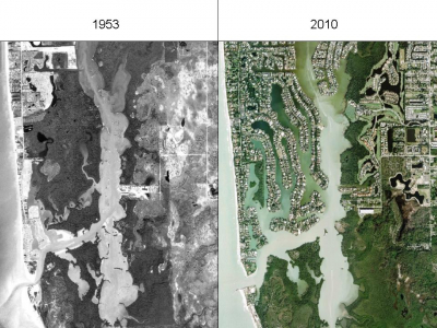
Naples Bay is a shallow, narrow estuarine system extending 10 km (6 mi) from the Golden Gate Dam (Weir #1) to Gordon Pass. Over the past few decades, the bay has undergone various man-made modifications. Mangrove wetlands were drained and channeled for development and urbanization with canals, seawalls, and bulkheads replacing 70% of fringing mangrove shorelines in the bay. Portions of the bay have been dredged to create a channel to support boat traffic. The amount of freshwater entering the bay has also been altered due to modifications in stormwater runoff drainage patterns. Historically, the Naples Bay watershed was approximately 26 km2 (10mi2), however the addition of the Golden Gate Canal increased the watershed to 310 km2 (120 mi2). The expanded watershed and use of the bay and estuary for stormwater management has greatly increased the amount of freshwater entering the bay. This has resulted in unnatural salinities, reduced water clarity, and increased sediment loads all of which have been identified as key stressors to the bay’s ecosystems.
Prior to the 1950s, there were approximately 50 acres of oyster reef habitat extending along both sides of the bay, with the greatest density of oyster habitat in the Haldeman Creek area, midway down the length of the bay. Seagrasses also once flourished throughout the bay, previously covering approximately 67 acres. A 2006 study found oyster reef habitat coverage had been reduced to only 12 acres, an 80% reduction in over five decades. Similarly, seagrass habitat also was found to have decreased by 91% to only 4 acres. Although Naples Bay cannot be restored to its former natural conditions, restoring oyster reefs is an important step to improve the bay’s health and function because oysters provide various underappreciated ecosystem services.

